Map & Caching
The Map setting (Settings → Map) chooses the background style: Full (the OpenStreetMap street map described below), Lo-fi (an offline vector map), or Off (a plain scope). This page is mostly about the Full raster map and its caching; the lo-fi map is covered at the end.
Where the map comes from
Frank's Flight Radar renders a real street map underneath the radar rings and aircraft, built from OpenStreetMap raster tiles (tile.openstreetmap.org). There's no map for the whole world stored on the device — tiles are fetched for the current home location and zoom radius, stitched together, and composited into a 240×240 sprite that becomes the radar's background.
Caching
Every composed map is written to the device's flash filesystem (LittleFS, on an ~1.5 MB partition) and is content-addressed by the exact latitude, longitude, and radius it was built for. This means:
- Switching between a zoom level or location you've visited before loads instantly from flash — no network fetch needed.
- A genuinely new combination (new zoom level, new location) fetches fresh tiles over WiFi, which takes a few seconds (a "loading map..." message is shown while this happens).
- The cache never needs to be manually cleared for correctness — old entries for locations/zooms you no longer use just sit unused. If the cache partition ever fills up, the least-recently-written entry is automatically evicted to make room for a new one.
Saved favourite locations are pre-cached automatically as soon as you save them, so switching to one is always instant.
Why tiles are decoded one at a time
The M5Dial's ESP32-S3 has no PSRAM — the map sprite alone (115 KB) plus PNG decode buffers plus the WiFi/TLS stack all have to share a ~320 KB RAM budget. Frank's Flight Radar streams each tile straight to a small flash-backed scratch file and decodes it directly from there, rather than holding a fully-buffered image in RAM, and the PNG decoder's own ~44 KB working buffer is deliberately released again right after a map composes, so it doesn't sit around competing with the more frequent flight-data network requests for the same scarce memory.
The lo-fi vector map
Set Map → Lo-fi for a lightweight, offline alternative to the street map: coastlines, national borders, rivers, and lakes drawn as themed lines, with labels for major cities and airports (by IATA code). Unlike the raster map, it has nothing to fetch or cache — the entire world (simplified Natural Earth data, public domain) is baked into the firmware and rendered directly.
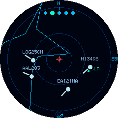
That makes it a good fit when you want geographic context without the weight of the street map:
- Works anywhere, offline — no tiles to download, so it's instant at every location and zoom, including places you've never visited.
- No "loading map…" pauses and no credit or bandwidth cost.
- Smooth while following — because there's nothing to recompose, following an aircraft re-centres instantly, with none of the periodic map reloads the Full map does.
- Themed — the lines recolour with your chosen colour theme.
It's deliberately low-detail — a scope-style geographic reference, not a substitute for the street map's roads and place detail. Coastlines are coarse and only larger towns are labelled.